Is this house in the wrong city?
A case for adjusting municipal boundaries

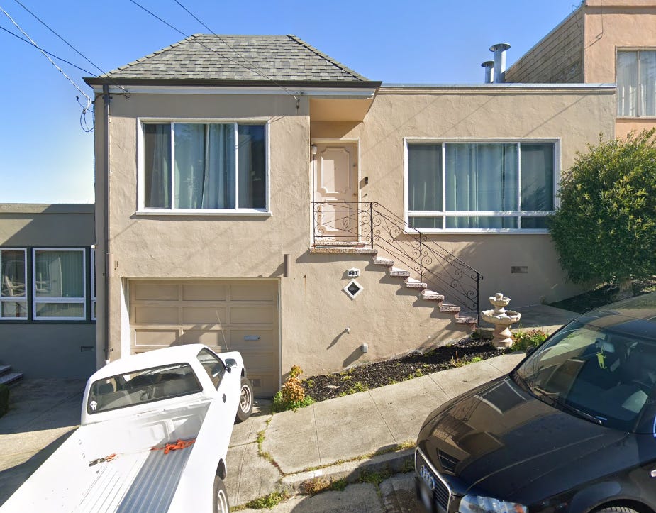
This is 55 Robinson Drive. By most measures, it is a fairly unremarkable single family home, of the sort one could find in any medium density suburban neighborhood. If you walk half a mile north, you’ll find the Crocker-Amazon Park. One and a half miles Northwest, there’s the Balboa Park BART and Muni Stations that can take you pretty much anywhere in San Francisco.
But the rub is that this house isn’t part of San Francisco. It’s part of Daly City. But if you walk along Robinson Drive, going Northwest to house number 43, or Northeast to house number 71, which takes less than two minutes, now you’re in San Francisco. This is because Robinson Drive, which forms a U shape when viewed from a map, happens to intersect the boundary line that defines the border between the counties of San Francisco and San Mateo

One might ask why the boundary is defined this way such that 25 or so houses on the southern part of Robinson Drive, as well as a number of other roads in the area, are cut off from their neighbors in San Francisco. This boundary is enshrined in law under California Government Code Sections 23138 and 23141. Section 23141, in turn, states that the county line is defined by a survey that was carried out in 1898 by the County Surveyors of San Francisco and San Mateo.
Back then, none of this land was developed, so it made sense to just draw a perfectly straight line across the San Francisco Peninsula to delineate the border between the two counties. At this point, there wasn’t even a Daly City. That particular municipality incorporated in 1911, more than a decade after the boundary survey. Even after incorporation, the land along the county boundary line was undeveloped. In all likelihood, Robinson Drive and its houses weren’t built until the post-WWII housing boom and the expansion of the suburbs. Whoever paved the street and parceled out the land for development was likely doing so with little consideration to the county lines, instead trying to shape the street and parcels around the natural topography of the hill upon which the street was built.

So what? Who cares that 55 Robinson Drive is part of Daly City, while 43 Robinson is in San Francisco? In the grand scheme of things, it may not matter all that much outside of being an interesting bit of trivia. But on the other hand, which city a particular house belongs to can matter a great deal depending on one’s circumstance.
Imagine being a parent living at 55 Robinson. Your daughter is about to enter school and you want to enroll her at nearby Guadalupe Elementary School because her friends up the road at numbers 41 and 39 are going to be attending that school. An eminently sensible idea. She’ll be entering school with a couple of friends, hopefully enhancing her learning experience by making the transition into a new social space less jarring. Meanwhile, you can set up a carpool with the parents, reducing the stress of your morning routine and cutting overall traffic in the area around the school.
But, you may not be able to since your house is technically in Daly City and the San Francisco Unified School District mandates residency within the City and County of San Francisco in order to enroll in its schools. You may be able to get an exception made considering your circumstances, but that’s not guaranteed, and, regardless, is going to be an unpleasant expenditure of time that your neighbors up the street don’t have to deal with. This same issue is going to impact a great many facets of your life. If you and your neighbors’ homes are burglarized, different police departments may need to perform duplicative investigations into the same crime and your respective District Attorneys will have to wrestle over who gets priority in charging. If your roads or sewers need repairs, different departments will have to take on those projects, which if not properly coordinated, may waste time and money while causing additional annoyance to you and your neighbors.
Why does this matter? Does the way one street is laid and how it interacts weirdly with municipal boundaries really carry such import that it merits the creation of a several hundred word article which will forever be etched into your brain? On its own, not necessarily. But the situation of 55 Robinson Street is emblematic of a broader issue surrounding how the lines and laws that define our cities fail to change to reflect the reality of what those cities look like on the ground.
Back in 1898, when Charles S. Tilton and William B. Gilbert made their survey of the San Francisco-San Mateo boundary line, San Francisco’s population was less than half of what it is now, with most of the southern reaches of the city being undeveloped farmland. San Mateo County, meanwhile, had a population of barely more than 10,000, with only two incorporated cities. Moreover, prior to the widespread adoption of the automobile and creation of the US Highway and Interstate system, travel between the counties, or even within counties was an onerous and time-consuming affair. Getting from the newly opened Ferry Building at the Northeast corner of San Francisco to San Bruno Mountain, which is arguably the point that really divides San Francisco from “The Peninsula” today, would have taken the better part of a day to travel.
In this context, it would be absurd to suggest that the city of San Francisco should be the entity to govern a small community that started growing on the Peninsula in the aftermath of the 1906 Earthquake. It was simply too distant for City Hall to govern effectively.
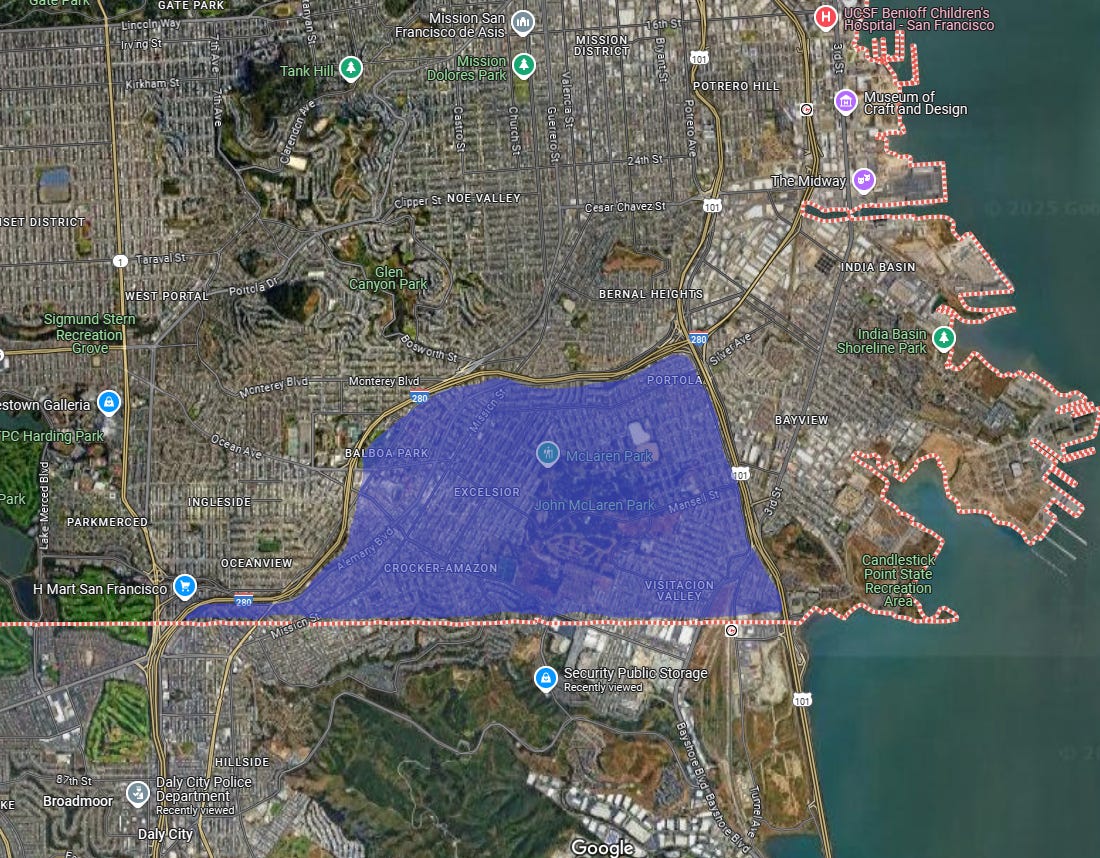
But that’s not the case anymore. The two cities have grown outwards to the point where they abut each other and the lines that divide city and county have become increasingly arbitrary. The advent of the car has enabled travel and the easy exchange of goods and services. Many of the residents of the Daly City neighborhoods east of Interstate 280 likely travel to, transact with, and look towards San Francisco more than they do the core of Daly City west of 280. Or perhaps it’s the other way around and the residents of the area of San Francisco bounded by 280 to the West and North, Highway 101 to the East, and the county line to the South, which includes the Excelsior, Crocker-Amazon, and Portola neighborhoods feel much more affinity with Daly City than they do with their “fellow” San Franciscans that live beyond those highways.
Regardless, though the borders that divide these cities made sense at the time they were drawn, they are no longer serving their purpose. These lines on a map, drawn arbitrarily at a time when drawing lines on maps made the most sense, can now have real negative consequences for the people living on top of them. As such they should be redrawn to better reflect the on-the-ground facts. Now is as good a time as any considering that we are apparently living in a time when our leaders say they want to redraw much bigger maps, much more forcefully.
Is there a way to do this? Yes, actually. The Cortese-Knox-Hertzberg Local Government Reorganization Act of 2000 creates a process whereby municipal boundaries can be changed in order to facilitate orderly development. This law has been used in places like Big Bear Lake and Anaheim to expand areas covered by city services, to mixed success. Given the political will to do so, the neighborhoods of Daly City abutting San Francisco could be integrated into the city, or the southern neighborhoods of SF could break away from the control of city hall to the north and incorporate with their southern neighbor.
Is this likely to happen? Probably not. The CKH process is slow, onerous, and requires buy-in from the affected members of the community. And as is painfully obvious to anyone that has watched a public comment session for a proposed housing development, when you ask “the community” what they think about any proposed change to a status quo, you’ll hear the voices of the loudest, angriest, and most change-averse people.