


Does Something Seem Off About This Picture?
And does it have anything to do with Marc Andreessen and Steph Curry?

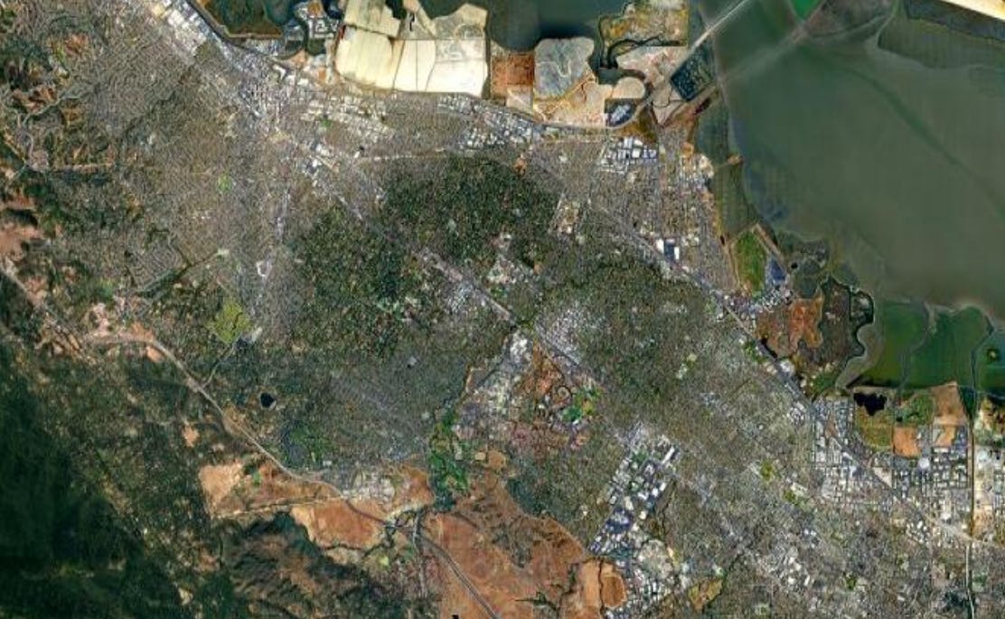
Look at this photograph1. Does anything seem weird about it to you? Obviously it’s a satellite photo of an area near some body of water featuring the telltale signs of human habitation such as roads and buildings. But notice that green-ish splotch in the middle?

What’s the deal with that?
Your first thought might be that it’s some sort of park. But contrast it with this photo of Central Park in Manhattan.

Notice how clean the break is between the park and the surrounding city. By contrast, the green splotch kind of tapers off at the edges. Beyond that, the green splotch is far too irregularly shaped to be any sort of municipal park or set aside green space, such as Golden Gate Park or the Presidio in San Francisco.

You may also be able to make out some signs of human habitation within the splotch, such as the outlines of roads and bright spots standing out from the greenery that look like the roofs of buildings.
But if the splotch is a residential area, why is it so much greener than the surrounding areas? What causes this one area to have more trees and grass than anywhere nearby?
As it turns out, this green splotch isn’t just a random neighborhood within a larger town or city. Rather it is the town of Atherton, CA.

That name alone may set off some alarm bells among the more astute in the audience. But sit down and don’t spoil the story for the rest of the class as to why the Atherton city boundaries can be seen from space.
Atherton is a town of about 7,000 situated in San Mateo county between Redwood City and Menlo Park. The city is notable for being the most expensive ZIP code in the US, home to noteworthy figures such as Marc Andreessen, Steph Curry, Elizabeth Holmes2, Eric Schmidt, and various other high rollers in the Silicon Valley Tech scene and beyond.
The town’s eye watering home prices and green geospatial footprint are not an accident, but the result of deliberate choices about what can be built in the town that show how seemingly innocuous rules within city zoning regulations can have impacts so large you can see them from space.
Taking a look at the city’s zoning code, one thing that stands out is how simple it is in comparison to other city zoning codes. There’s only two types of residential districts3, R1-A and R1-B, both of which are single family only zones that mandate a minimum lot size of one acre (43,560 Sq Ft.). Moreover, the zoning code states that the first floor of the main building on a property can’t be greater than 7.5% of the lot size and the total floor area can’t be greater than 18% the area of the lot. Allowances are made for other structures like garages, pools, tennis courts, verandas, etc. that allow for a bit more space to be taken up, but fundamentally, the Atherton zoning rules mandating large lots with relatively small buildings in effect mandates giant yards filled with the lawns and trees that give the city its green appearance when viewed from above.
Contrast Atherton with its neighbor to the southeast, Menlo Park, where the two main single family residential zones have a minimum lot size of 7,000-10,000 Sq. Ft. and a maximum floor area of 35-40% depending on the number of stories on the building. Unsurprisingly, Menlo Park looks far less green when viewed from above because its houses take up a larger share of any given lot, leaving less space for lawns and trees.
These restrictions also help to explain the eye watering prices of homes in Atherton. Imagine you own an acre of undeveloped land in a single family district of some parallel universe Atherton with the minimum lot sizes of Menlo Park. Say you paid $2,000,0004 for the land and want to sell it. You could either sell the whole lot to a general partner at a venture capital firm for $2,500,000, or you could subdivide the lot into 5 smaller lots that you can sell to 5 analysts at her firm for $500,000 a piece. You make the same amount of money either way and there’s a lot more analysts with the ability to pay 500k than general partners who can pay 2.5m. However, Atherton’s minimum lot sizes foreclose the second option, restricting land ownership to only the people with the money to buy an acres’ worth of land on the San Francisco Peninsula.
It’s worth noting that some of Atherton’s building regulations have recently been overridden by state law, such as its “one house per lot” rule which was weakened by SB9, which grants the right to build accessory dwelling units (ADU) on the property even if local zoning regulations prohibit it. But the damage has already been done. Thanks to decades of restrictive zoning, the people of Atherton are overwhelmingly wealthy, such as the aforementioned Andreesen and Curry, and are hostile to the idea of housing being built in their wealthy enclave. As such, their elected representatives are incentivized to do whatever they can to stop housing from being built, including proposing to adopt a city charter to sidestep ADU regulations and closing the city’s Caltrain station.
But beyond its intersection with the perennially relevant housing debate, Atherton’s green footprint is a testament to the idea that, if you see something weird out in the world, its root cause probably has to do with some obscure regulation.
Every time I do it makes me laugh
Before she went to jail
San Francisco has more than 60 zoning districts. But it’s also 100x larger. So that may not be the best comparison.
In reality, you’d have to pay closer to $12,000,000 an acre, but just assume this price for the sake of argument.